Mapping Armed Groups in Eastern Congo – 4th Edition
Regular readers may have noticed that this website features a mapping of armed groups in eastern Congo which is periodically updated and refined (three times a year). Today, the 4th edition of this complicated and always unfinished exercise goes online and adds to the yet existing mappings.
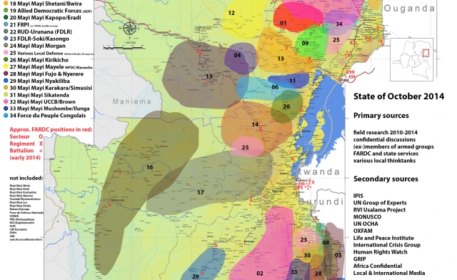
As stated repeatedly in the lengthy disclaimer necessary due to the political connotations and dangers of misinterpreting this work, it makes sense to also here underline the following explanations:
The mapping describes the yones of influence, not necessarily full control, for the indicated armed groups and fixed (official) positions for the national army. Changes in the subsequent maps reflect either changes on the ground or (for the time being) refinements relating to improved information.
This exercise does not entail any claim of full accuracy and merely represents an approximate assessment of the situation with uncertainty and potential errors always remaining.
As earlier mappings, this edition runs under a creative commons license and can be republished or used according to the respective rules.
The mapping section also has a short genealogical sketch of armed actors in the region upcoming, so stay tuned. In the meantime, feel free to comment on the map and provide differing opinions and corrections where applicable.
Comments
2 Responses to “Mapping Armed Groups in Eastern Congo – 4th Edition”Trackbacks
Check out what others are saying...-
[…] the DRC, like Mexico, more than 1,000 are highly likely to die. However, the splintered nature of armed groups in the country’s east means I think it’s more likely than not no single group will kill […]

Reblogged this on My Ciluba.